Assessing Tree Canopy Loss
Renee Grebe // Nature Forward // renee.grebe@natureforward.org
Ann Jurczyk // Chesapeake Bay Foundation // ajurczyk@cbf.org
Land & Wildlife Conservation
Executive Summary
Virginia continues to lose both intact forest and urban tree canopy at an alarming rate. Despite committing to expand tree canopy in its Phase III WIP, Virginia suffered a net loss of 9,5481 acres between 2014-2018. Because canopy loss contributes to degraded waterways and Virginia’s ability to protect its residents from the impacts of climate change, such as inland flooding and negative health consequences of urban heat islands,2 Virginia needs to assess where and why canopy is lost and then address the findings through a mix of state regulation, incentives, and education as we move towards becoming a no-net loss state.
Challenge
It is easy to find examples of forested lands being cleared or an individual tree being removed, but understanding these losses in aggregate – how many acres are lost statewide and why – is more challenging. High-resolution land cover data became available for the Chesapeake Bay watershed states in 2020, which led to an understanding of the net change in forest and tree canopy by jurisdiction and forest transitions to other land covers and uses. But questions remain that, if answered, would drive Virginia to take steps to slow and eventually reverse the loss.
For example, how healthy are Virginia’s forests? How many acres of canopy have been lost to emerald ash borer and where? Where do forest fragments exist (fragments are more susceptible to invasive species)? Which localities are being impacted by infrastructure projects such as road and energy right-of-way expansions? How is saltwater intrusion impacting coastal tree canopy? How are infill development and exurban sprawl reducing the number of mature trees in neighborhoods? Where are homeowners removing healthy trees and why? How can we be sure tree canopy is equitably distributed?3
It takes decades for new trees to provide full carbon reduction, water, air, and wildlife benefits – time is of the essence.
Virginia needs a baseline understanding of its forest and urban tree canopy and a tree canopy analysis at a local scale that provides context for the loss, the “why.”

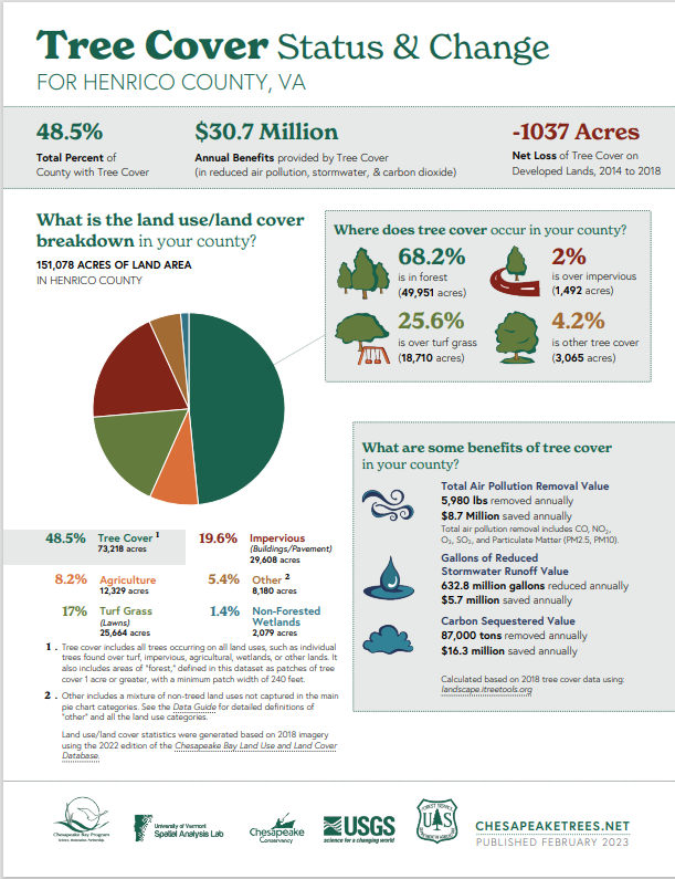
Locality datasheets4 illustrate how tree canopy changed over time, but left many unanswered questions. See https://chesapeaketrees.net/understand-your-canopy to discover the changes in your locality.
Solution
The high-resolution land cover data shows land use changes between 2014 and 2018, illustrating how many acres changed from forest to impervious surface for instance.3 An updated land cover dataset will be released in early 2024, showing land use changes between 2018-2022. We anticipate seeing that canopy loss has accelerated since 2018 due to increased development activities, road expansion, energy infrastructure expansions, disease, and homeowner removal. As soon as new data is available, completing an updated technical assessment of Virginia’s tree canopy will build awareness and understanding of Virginia’s tree canopy loss so that legislators, homeowners, local government planners, and elected leaders can take steps to address and hopefully reverse the trend.
This assessment will also help local governments establish the need for additional authority to better manage their tree canopy, such as establishing a tree fund and setting a floor on tree canopy replacement percentages when land is developed at no less than amounts in current code.
Not understanding the pace and drivers of loss contributes to a lack of urgency to find funding, program, and policy solutions to address it. Since it takes decades for newly planted trees to provide the carbon reduction, water and air quality, and wildlife benefits of mature trees, time is of the essence. For the state to achieve no net loss, we will need to adopt measures that protect existing canopy and replace what cannot be preserved.
Policy Recommendations
$500,000 for DOF to fund a statewide tree canopy and forest health assessment using the high-resolution 2018-2022 dataset to determine the drivers of forest and urban tree canopy loss, including disease (EAB), infrastructure (road widening and linear energy corridors), in-fill and greenfield development, saltwater intrusion, and homeowner removal.
End Notes
1 “Tree Canopy.” Chesapeake Progress (Accessed June 27, 2023). https://www.chesapeakeprogress.com/abundant-life/tree-canopy.
2 “Climate Change And Health In Virginia Extreme Heat Is Bad For Virginians’ Health- And Could Become More Deadly,” NRDC (2018). https://www.nrdc.org/sites/default/files/climate-change-health-impacts-virginia-ib.pdf.
3 Brad Plumer and Nadja Popovich, “How Decades of Racist Housing Policy Left Neighborhoods Sweltering,” The New York Times (August 24, 2020). https://www.nytimes.com/interactive/2020/08/24/climate/racism-redlining-cities-global-warming.html.
4 “Chesapeake Bay Program Land Use/Land Cover Data Project.” Chesapeake Conservancy (Accessed June 27, 2023). https://www.chesapeakeconservancy.org/conservation-innovation-center/high-resolution-data/lulc-data-project-2022/.
